
Oasis Circular No.: 2302
Date: 03 Feb 202
Subject: Shanghai MSA issued notice on strengthening vessel traffic management in Changjiangkou and its adjacent waters effective from 01 Feb 2023
Shanghai MSA recently issued “Notice on strengthening vessel traffic management in Changjiangkou and its adjacent waters”, which has come into force as of 01 Feb 2023, in order to prevent and reduce the risk of vessel collision accidents in this area. Following this, Wusong MSA, a sub-branch of Shanghai MSA published a further circular with their interpretation on this Notice to assist in the understanding of the relevant requirements. The main points are summarized as follows:
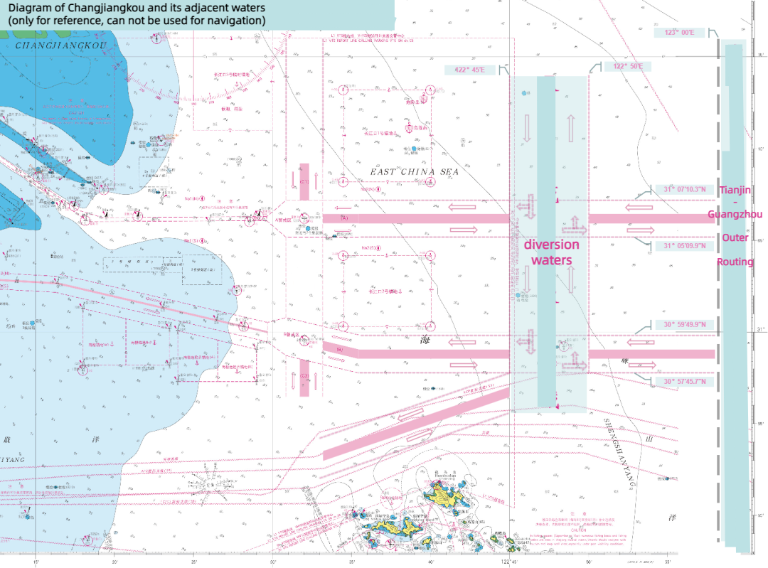
Diagram of Changjiangkou and its adjacent waters
Background
Changjiangkou is an essential place for ships sailing to and from the Yangtze River and Shanghai Port, as well as ships navigating southward or northward along the coast. At present, an average of over 1,000 ships pass by this area, mostly ships entering or leaving the North/South Channel or passing by in the north-south line. In these waters, there are a variety of ship types, including big size ships which can either be anchoring or passing by. The fact that Changjiangkou Ship Routing System includes both east-west and south-north channels, plus the heavy traffic in the anchorage, often causes complex navigational situation involving multiple ships.
Aim of the Notice
In order to prevent and reduce the risk of vessel collision accidents in Changjiangkou and its adjacent waters, relieve navigation pressure in the Precautionary Areas A and B, improve the overall navigational efficiency, and ensure the safe, well organized and smooth maritime traffic, in accordance with the Maritime Traffic Safety Law of the People’s Republic of China and Changjiangkou Ship Routing System (2008), the separation of ship traffic flow in Changjiangkou and its adjacent waters shown in the diagram below.
Interpretation of the Notice
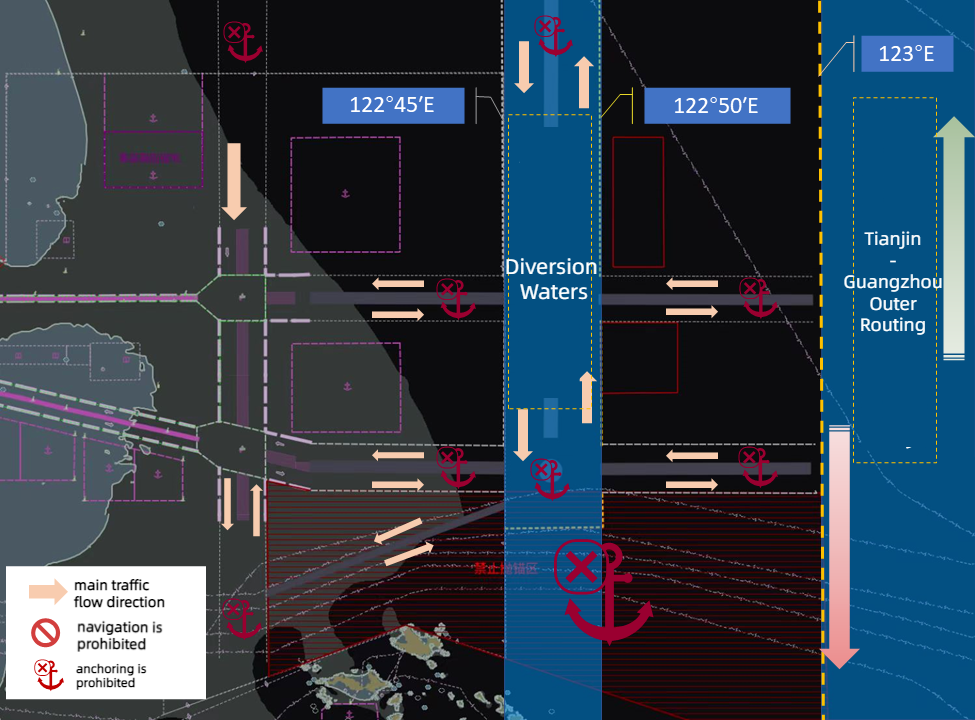
Sketch Map of Ship Traffic Organization in Changjiakou Waters
1. Recommended routing for passing by vessels navigating from south or north
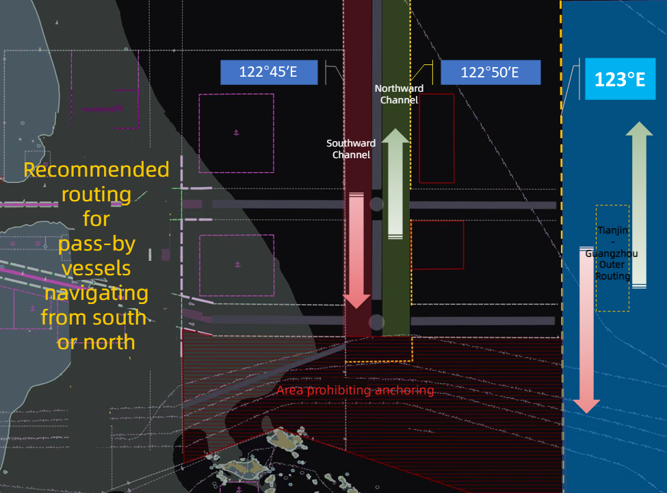
The passing by vessels from south or north navigate in Changjiangkou and its adjacent waters are recommended to choose the Tianjin-Guangzhou Outer Routing (the north-south customary route along the longitude 123 °00 ′E) or the diversion waters. (between longitude 122 °45 ′E and 122 °50 ′E)
2. Wusong VTS Ship Traffic Organization
If it is safe and feasible, vessels passing through the Precautionary Areas A and B of the Changjiangkou Traffic Separation Schemes (CJK TSS) shall give priority to the following navigation suggestions and navigate under VTS’s organization:
2.1
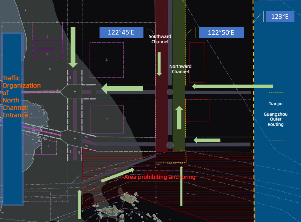
Inbound vessels proceeding to Changjiangkou Deepwater Channel ( North channel ) from Changjiangkou waters shall make turns in the Precautionary Area A through the traffic lane C1 of CJK TSS, or turn into the traffic lane A through the diversion waters or the Tianjin-Guangzhou Outer Routing.
2.2
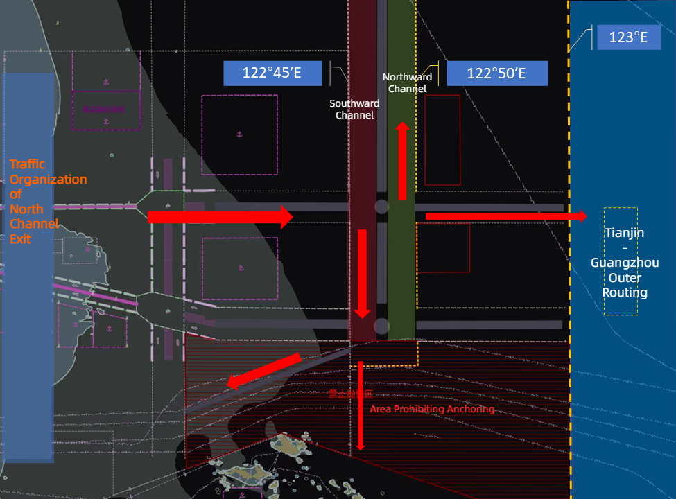
Outbound vessels sailing from Deepwater Channel to Changjiangkou waters, and intending to turn northward or southward, shall proceed eastward by TSS lane A, and make turns in the diversion waters or the Tianjin-Guangzhou Outer Routing.
2.3
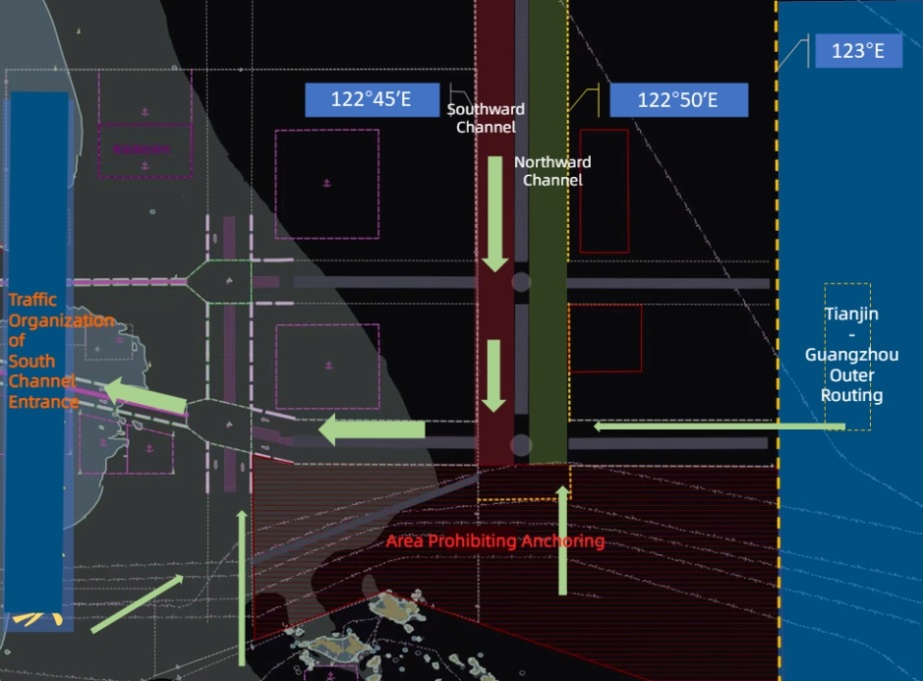
Inbound vessels proceeding to South Channel from Changjiangkou waters, shall take turns in the Precautionary Area B through the TSS traffic lane C3, or turn to TSS traffic lane B through the diversion waters or Tianjin-Guangzhou Outer Routing.
2.4
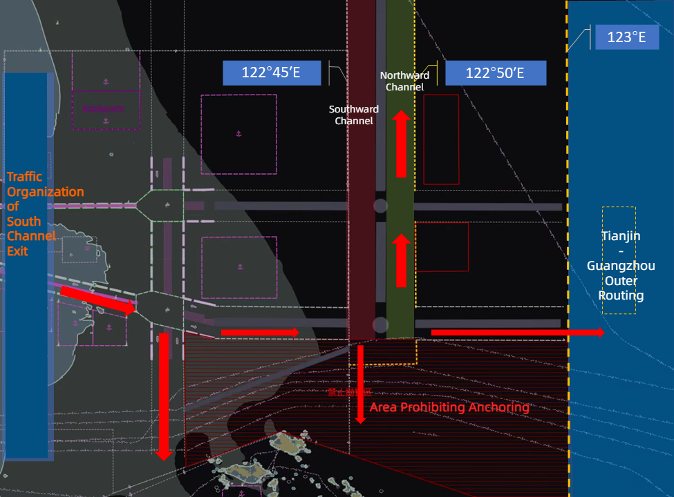
Outbound vessels sailing from South Channel to Changjiangkou waters, and intending to turn northward or southward, shall proceed eastward by the TSS traffic lane B, and make turns in the diversion waters or the Tianjin-Guangzhou Outer Routing. Vessels intending to turn to south could also make turns in the Precautionary Area B.
3. Precautions for navigation
Vessels shall make the voyage plan according to the navigation environment and hydro-meteorological conditions, taking into account their own maneuverability, performance of wind resistance, distribution of fishing vessels and fishing nets and other factors, comply with the on-site traffic organization measures taken by VTS to guarantee navigational safety and efficiency, and comply with the International Convention on the rules of collision avoidance by sea (1972) and Changjiangkou Ship Routing System (2008) and other relevant provisions.
4. Requirements for ship anchoring
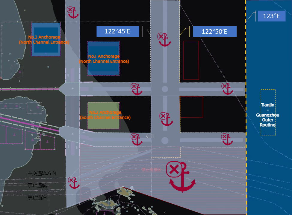
Vessels shall reasonably select the anchorage according to the sailing plan, ship tonnage, etc. Vessels shall verify their intentions with other vessels to avoid collision when entering or leaving the anchorage. Vessels shall not anchor in the Diversion waters, and shall report to VTS immediately when dropping anchor in an emergency.
5. Precautions for Sailing in the South Channel
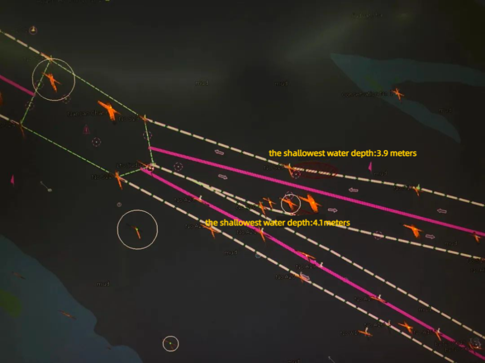
Vessels sailing through the Jiuduansha Precautionary Area to the South Channel Pilot Waters in strong wind and waves condition, shall pay attention to the water depth changes near the channel boundary.
We hope the above is of assistance. Owners are always recommended to check with the local agent for the latest requirement and information in case of need.
If there is any query, please feel free to contact us at oasis@oasispandi.com anytime.
Best regards,
Oasis P&I Services Company Limited
Appendix
Notice of Shanghai Maritime Safety Administration on Further Strengthening Vessel Traffic Management in Changjiangkou and its adjacent waters
(translated by Wusong MSA)
(In case there is any discrepancy between the Chinese edition and the English edition, the Chinese edition shall prevail)
In order to prevent and reduce the risk of vessel collision accidents in Changjiangkou and its adjacent waters, relieve navigation pressure in the Precautionary Areas A and B, improve the overall navigational efficiency, and ensure the safe, well organized and smooth maritime traffic, in accordance with the Maritime Traffic Safety Law of the People’s Republic of China and Changjiangkou Ship Routing System (2008), the separation of ship traffic flow in Changjiangkou and its adjacent waters is guided as follows:
1. The pass-by vessels from south or north navigate in Changjiangkou and its adjacent waters shall prefer to choose the Tianjin-Guangzhou Outer Routing (the north-south customary route along the longitude 123 °00 ′E) or the diversion waters. ( between longitude 122 °45 ′E and 122 °50 ′E)
2. If it is safe and feasible, vessels passing through the Precautionary Areas A and B of the Changjiangkou Traffic Separation Schemes (CJK TSS) shall give priority to the following navigation suggestions and navigate under VTS’s organization:
2.1 Inbound vessels proceeding to Changjiangkou Deepwater Channel ( North channel ) from Changjiangkou waters shall take turns in the Precautionary Area A through the traffic lane C1 of CJK TSS, or turn into the traffic lane A through the diversion waters or the Tianjin-Guangzhou Outer Routing.
2.2 Outbound vessels sailing from Deepwater Channel to Changjiangkou waters, and intending to turn northward or southward, shall proceed eastward by TSS lane A, and take turns in the diversion waters or the Tianjin-Guangzhou Outer Routing.
2.3 Inbound vessels proceeding to South Channel from Changjiangkou waters, shall take turns in the Precautionary Area B through the TSS traffic lane C3, or turn to TSS traffic lane B through the diversion waters or Tianjin-Guangzhou Outer Routing.
2.4 Outbound vessels sailing from South Channel to Changjiangkou waters, and intending to turn northward or southward, shall proceed eastward by the TSS traffic lane B, and take turns in the diversion waters or the Tianjin-Guangzhou Outer Routing. Vessels intending to turn to south could also take turns in the Precautionary Area B.
3. Vessels shall make the voyage plan according to the navigation environment and hydro-meteorological conditions, taking into account their own manoeuvrability, performance of wind resistance, distribution of fishing vessels and fishing nets and other factors, comply with the on-site traffic organization measures taken by VTS to guarantee navigation safety and efficiency, and comply with the International Convention on the rules of collision avoidance by sea (1972) and Changjiangkou Ship Routing System (2008) and other relevant provisions.
4. Vessels shall reasonably select the anchorage according to the sailing plan, ship tonnage, etc. Vessels shall verify their intentions with other vessels to avoid collision when entering or leaving the anchorage. Vessels shall not anchor in the Diversion waters, and shall report to VTS immediately when dropping anchor in an emergency.
5. Vessels sailing through the Jiuduansha Precautionary Area to the South Channel Pilot Waters in strong wind and waves condition, shall pay attention to the water depth changes near the channel boundary.
6. This circular shall come into force on 1 February 2023 and be valid until 31 January 2026.
Shanghai Maritime Safety Administration
26 December 2022
Copyright 2017 All Rights Reserved Oasis P&I Services Ltd. 沪ICP备88888888号
